Cape Queen Elizabeth

Traversing Cape Queen Elizabeth

While camping on Bruny Island, which you can read about here, we went for a bushwalk. Our destination was Cape Queen Elizabeth and I wasn’t sure what to expect. By chance, we timed our walk at low tide which turned out to be a very good thing!

Big Lagoon
Big Lagoon © emily@traversingtasmania 2017

The walk to Cape Queen Elizabeth begins with a car park and a 4WD track. Although it’s not the most scenic part of the walk, do take the time to admire the flora. It’s beautiful! The 4WD track takes you past the aptly named Big Lagoon which is, well, big! It’s also visible from the tip of Cape Queen Elizabeth so be sure to look out for it. After big lagoon, you’ll continue down the track for a few hundred metres before having a choice to make: beach or bluff? You can only make it across the beach during low tide. We had a quick look at this website to see if it was low tide in Adventure Bay and fortunately it was! We took the walk along the beach.

Rock Formations at Mars Bluff
Rock Formations at Mars Bluff © emily@traversingtasmania 2017

If you can’t quite manage the whole 3 – 4 hour walk to the point of Cape Queen Elizabeth, a good second would be to at least make it to Mars Bluff via Neck Beach at low tide. The rock formations are exceptionally beautiful from the beach! You’ll also have views of Cape Queen Elizabeth from the beach, framed by towering cliffs. Round the first cliff and you’ll find a crevice to explore. This takes you through to another beach. There are caves to explore here, including one that is uniquely rectangular! The water reaches into these caves at high tide so please make sure that you’re well out of the way by then. Rock formations can collapse at any time and you do explore these areas at your own risk.

Mars Bluff Cave
Mars Bluff Cave © emily@traversingtasmania 2017
Arch on Bruny Island
Arch on Bruny Island © emily@traversingtasmania 2017

Another highlight of Mars Bluff, which you’ll find around the next cliff, is the arch. I walked past it without even noticing it at first as it is so huge! It is an imposing natural structure. My husband climbed on top of it. I was content just to walk through it and photograph it! Make sure that you time your walk to coincide with low tide as the arch is unique and worth making the extra effort to see.

View from Cape Queen Elizabeth
View from Cape Queen Elizabeth © emily@traversingtasmania 2017

From the arch, walk to Miles Beach. I didn’t know this at the time, but there is a fisherman’s shack to be seen in the dunes at the eastern end of the beach. While at the eastern end of Miles Beach, take note of the location of a white pole. This is where you’ll need to go if the tide is too high for you to return via the shore. When we walked across it, Miles Beach was littered with crab shells and the sand had been shaped into intriguing patterns by the wind and waves. At the end of Miles Beach, there is another white pole, signalling the start of the walking track to Cape Queen Elizabeth.

Mutton Bird Rookery
Mutton Bird Rookery © emily@traversingtasmania 2017

The walking track again leads you through native flora. This time, you’ll see stunning white gums, stands of tea-tree and a mutton bird (short-tailed shearwater) rookery. Make sure that you stay on the track and take your rubbish with you to protect the birds. When you reach a fork in the path, take the left turn (an arrow made from rocks is on the ground to guide you). This takes you up to the tip of Cape Queen Elizabeth.

View from Cape Queen Elizabeth
View from Cape Queen Elizabeth © emily@traversingtasmania 2017

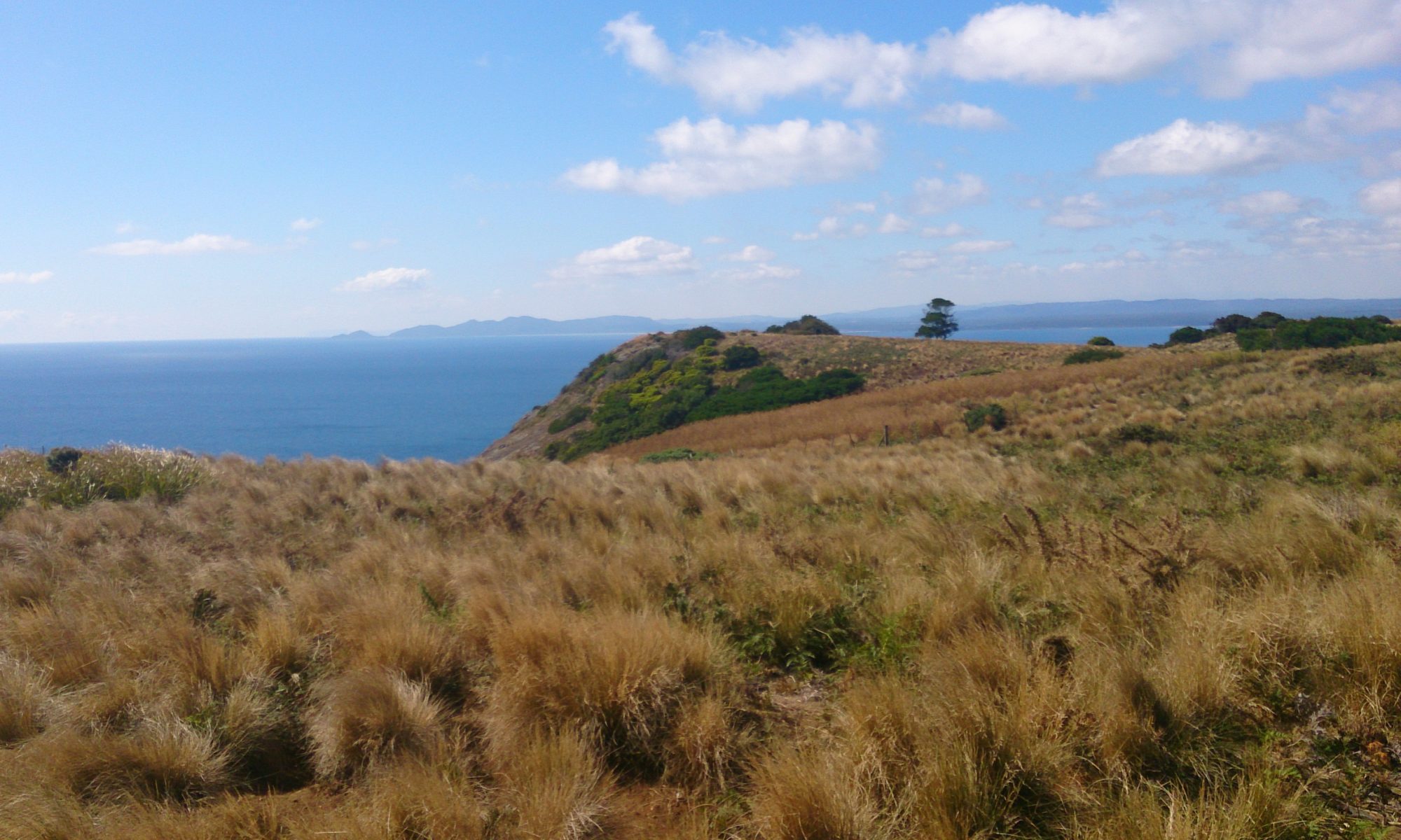
There are two main vantage points. The lower one affords stunning views of Adventure Bay and Fluted Cape. The higher vantage point gives you views of the rest of Cape Queen Elizabeth, down into a crevasse (take care), and on to the shadowy forms of what must be the Tasman Peninsula!

What to Bring

View of Tasman Peninsula
View of Tasman Peninsula © emily@traversingtasmania 2017

As it’s a 3 – 4 Hour walk, you will need to carry at least a litre of water per person, food, sunscreen, a hat, a basic first-aid kit and good walking shoes. From experience, I recommend wearing thick socks and/or bandaging your feet to prevent blisters with newer shoes. I also recommend wearing layers for warmth and taking waterproof gear if rain is forecast. Finally, remember your camera to take some amazing photos! It’s also handy to have your phone with you. I used mine to check tide times and a map of the track on the go.

Getting There

Cape Queen Elizabeth
Cape Queen Elizabeth © emily@traversingtasmania 2017

For directions to Bruny Island, see my instructions at the bottom of my general post about Bruny Island here. Once you’re on Bruny, head south towards The Neck (follow signs from the ferry for Alonnah and Adventure Bay). Before you reach The Neck, you’ll see Bruny Island Honey on the right. Directly opposite this is the car park for the Cape Queen Elizabeth Walking Track. You know you’ve gone too far if you pass the airstrip.

Cost

There is no cost to walk the Cape Queen Elizabeth Walking Track. Make sure that you take care of the track by taking any rubbish that you see out with you.

To read more of my posts about Bruny Island, click here. For posts about southern Tasmania, click here.
The Neck Game Reserve Camp Ground

Traversing Neck Beach

This week, we camped with a friend on Bruny Island at The Neck Game Reserve Camp Ground. We had three days of unseasonably warm weather. The sky was gorgeous, bird-life was plentiful and the sound of the waves crashing against the shore lulled us to sleep.

Sunrise
Sunrise © emily@traversingtasmania 2017

There’s something wonderful about waking up to bird-calls and sunlight shining through trees. There’s something even more wonderful about strolling down to the beach, watching the sun rise higher and joining the short-tailed shearwaters paddling in the shallows. The Neck Game Reserve Camp Ground is right next to Neck Beach, with just the dunes separating the two areas. It is a spectacular piece of coastline.

View from The Neck Lookout to Cape Queen Elizabeth
View from The Neck Lookout to Cape Queen Elizabeth © emily@traversingtasmania 2017

We arrived at the camp ground at about 2pm. After we had set up camp, we walked back to The Neck Lookout. We dawdled, taking photographs, admiring the birds, and even stopping for a rest, and it took us about an hour and a half to get there. The Neck Lookout is unique as it is a rookery for both mutton birds (short-tailed shearwaters) and penguins. We could hear the penguins but it became too dark to see them (and we had a long walk back to the campsite). Next time, I’ll take a red-light torch (or even just a piece of red cellophane to put over a standard torch) so that I can see them at night! Make sure that you take care of the penguins by staying on the paths, taking all rubbish with you and not shining bright lights (including camera flashes) in their eyes.

Facilities

The Neck Game Reserve Camp Ground
The Neck Game Reserve Camp Ground © emily@traversingtasmania 2017

The Neck Game Reserve Camp Ground has about thirty unpowered sites. When we were there, we shared the camp ground with caravans, campervans, 4WDs with pods on top, and even a cyclist with a tiny tent who was cycling the 60kms to Hobart the next day. It was a nice atmosphere and everyone was very respectful (toilet lid down, quiet at night, sleep-in in the morning… marvellous!).

Day Use Area
Day Use Area © emily@traversingtasmania 2017

Two pit toilets are available for use in two different locations. This means that the toilets are within easy reach of most sites. When we arrived, there was no running water but water was available the next day. To drink this untreated water, you’ll need to boil it for three minutes at a rolling boil. We brought our own drinking water and just used the water there for washing up. There are two picnic tables and a fireplace for day use. Camp fires are allowed at your site too, although you’ll need to bring your own firewood. I recommend also bringing your own fold up chairs, table and cooker to make cooking and eating at your site that bit more enjoyable.

Getting There

View of Neck Beach
View of Neck Beach © emily@traversingtasmania 2017

For instructions on getting to Bruny Island, read my post about the island here. Once you’re on Bruny, head south towards The Neck. Follow signs from the ferry for Alonnah and Adventure Bay. Once you’ve passed The Neck Lookout, you’re close! A few kilometres down the road, you’ll see blue signs to The Neck Game Reserve Camp Ground on the left.

Cost

Paddling with Birds
Paddling with Birds © emily@traversingtasmania 2017

Camping at The Neck Game Reserve Camp Ground costs $10 per site (for two adults) and $5 for each extra adult. We paid $30 for two nights which is an absolute bargain considering the scenery! For up to date prices, see Parks and Wildlife’s information here. Sites are not able to be booked in advance and you will need cash (and a pen) in order to pay the fees via the self-registration box at the camp ground.

To read more of my posts about Bruny Island, click here. For posts about southern Tasmania, click here.

Bruny Island

Traversing Bruny Island

Bruny Island lies off the coast of Southern Tasmania, about half an hour’s drive south of Hobart. It is roughly 100 kilometres long and boasts some of Tasmania’s finest produce, wilderness and attractions.

View from The Neck
View from The Neck © emily@traversingtasmania 2017

The island is divided into two halves: North Bruny and South Bruny. The ferry from Kettering (mainland Tasmania) arrives at Roberts Point on North Bruny. There are small settlements at the beautiful Dennes Point and Barnes Bay (follow signs from the ferry terminal). If you keep driving south, you’ll end up at the cheese factory, oyster bar and scenic flight base. Once you’ve passed these places, you will arrive at a thin strip of land joining North and South Bruny: The Neck.

The Neck
The Neck © emily@traversingtasmania 2017

It is worth stopping at The Neck, even if you’ve been to Bruny Island before. Climb the wooden stairs and see the ever-changing view of Bruny. You should also read the information about the original inhabitants of Bruny Island such as Truganini. If you are at The Neck at dusk, stop and watch the penguins emerging from the water. Take a red-light torch for optimal viewing without disturbing the penguins too much and make sure that you keep to the paths rather than damaging the penguins’ burrows.

Adventure Bay
Adventure Bay © emily@traversingtasmania 2017

Heading south from The Neck, you have choices! You could turn left to Adventure Bay. This is a beautiful, sweeping bay with stellar views, a caravan park and a nice little café (The Penguin). You can also catch a Pennicott Wilderness Journeys’ Bruny Island Cruises tour from Adventure Bay (read about my experience here) or you can walk to the ruins of the whaling station at Grass Point. There is a general store with an ATM at Adventure Bay.

Cloudy Bay Lagoon
Cloudy Bay Lagoon © emily@traversingtasmania 2017

If, instead, you turn left after The Neck, you’ll find your way to Alonnah and Lunawunna. lunawunna allonnah is the Aboriginal name for Bruny Island. At Alonnah, Hotel Bruny has a lovely view and serves a fine meal, happily catering for dietary requirements upon request. There is also a general store and History Room at Alonnah. After driving through Lunawunna, you have two choices. You can turn left towards Cloudy Bay for excellent camping and surfing, as well as access to South Bruny National Park. Or, you can turn right towards Cape Bruny Lighthouse (you can read about my experiences here), as well as access to another part of South Bruny National Park.

Barnes Bay
Barnes Bay © emily@traversingtasmania 2017

Wherever you choose to be on Bruny, you can expect good food, superb scenery and space to relax. Make sure that you check opening hours as some places vary their hours seasonally. Take a good book, a bit of cash, a full tank of petrol and clothes for all seasons and you’ll have a lovely time.

Getting There

Mirambeena
Mirambeena © emily@traversingtasmania 2017

If you have a car, simply take the vehicle ferry from Kettering. The current timetable is available here; make sure that you arrive 30 minutes prior to your scheduled departure and that you bring cash or a payWave capable card (EFTPOS or credit cards requiring pins/signatures cannnot be used). While petrol is available at some locations on Bruny, fill your car up before you venture over for maximum relaxation time. Hire cars can be problematic. Some hire car companies won’t allow you to drive their vehicles on Bruny Island due to the amount of dirt roads and consequent traffic incidents involving inexperienced drivers. Your GPS system may also cut out as phone reception has “black spots” on Bruny Island. Everything is well sign-posted though. If you’d prefer not to take a car onto Bruny, book a tour with one of the local companies.

Cost

Bruny Island's southern tip
Bruny Island’s southern tip © emily@traversingtasmania 2017

Getting to Bruny currently costs $33 per car (prices are seasonal and dependent on vehicle size; click here for current rates). Food, supplies, fuel etc. are all reasonably priced, considering that you’re on a small island, but accommodation can be a bit expensive. You’re paying for the privilege of staying on Bruny. It’s a unique, unforgettable island and is well worth a visit… and another visit… and another…

To read more about my travels in Tasmania’s south, click here.

Cape Bruny Lighthouse

Traversing Cape Bruny Lighthouse
Cape Bruny
Cape Bruny © emily@traversingtasmania 2017

Cape Bruny Lighthouse is a sturdy yet elegant lighthouse. Due to being made from sterner stuff than other historic lighthouses, it now boasts being the second oldest original lighthouse in Australia. It was Australia’s fourth lighthouse at its time of lighting in 1838. Constructed by convicts from local dolerite, the lighthouse took just 18 months to build. The three keepers cottages still sit below it, as does a graveyard, the ruins of a convict vegetable garden and some of the best scenery in the world.

Cape Bruny Lighthouse
Cape Bruny Lighthouse © emily@traversingtasmania 2017

Cape Bruny Lighthouse is a monument to times gone by. Now replaced by an automated light on the tip of the cape, the old lighthouse was recently restored internally and opened to the public for tours. You can book a tour online or at the base of the lighthouse on the day. Tours go up the tower every half hour. We had a private tour, which was lovely. The guide was friendly and knowledgeable. His boss grew up in various lighthouses around the state as the child of one of Tasmania’s last lighthouse keepers.

Fresnel prism
Fresnel prism © emily@traversingtasmania 2017

Inside, you’ll find a beautiful metal spiral staircase, the original Fresnel prism, kerosene vents, the weight system used for keeping the light revolving and a working phone to the keeper’s cottage. You end up circling the lighthouse on its balcony. We saw a wedge-tail eagle from above (they have a stunning pattern on their wings which you can’t see from the ground). It is breathtaking to view the D’Entrecasteaux Channel, the Southern Ocean and the southern tip of Bruny Island from above.

Cape Bruny
Cape Bruny © emily@traversingtasmania 2017
The Lighthouse Station
The Lighthouse Station © emily@traversingtasmania 2017

Once you are on the ground again, enter the museum for a glimpse of the machinery that made it all happen. The museum also houses artefacts found on site (ceramics, name plates, etc.). From the left-hand side of the Number 1 Keepers Cottage, take a walk down to the beach, past a small graveyard and the ruins of a convict garden. The Tasmanian flora in South Bruny National Park is magnificent. Watch out for my least favourite of all Tasmanian fauna: the Tasmanian Tiger snake. If you do come across one, make a decision to run or stand very still and make sure that you commit to your decision 100% as half-doing either option is not worth it!

Getting There

Convict Garden
Convict Garden © emily@traversingtasmania 2017

To get to Bruny Island, follow the advice in my Bruny Island post. Drive south from Alonnah, turning right at the T-junction near Lunawanna. Follow signs for Cape Bruny Lighthouse. The road is primarily gravel and is quite rough. There are two scenic lookouts on the way; stop at both. There is parking at the lighthouse although it is only a small carpark so you may have to park alongside the road – don’t block the driveways to the keepers cottages as two of these contain residents (the third is the museum).

Cost

View from the Lighthouse
View from the Lighthouse © emily@traversingtasmania 2017

Tours up the lighthouse (highly recommended!) are $10 per adult, $7.50 per child or $35 per family (not suitable for children under 5 years old).  You can book your tickets online here. This is recommended as tours can book out because they are for only eight people at a time. If you do book online, keep your booking number to quote for the guide. For those who arrive at Cape Bruny Lighthouse without a booking, it is worth the half hour wait. The views from the lighthouse are spectacular.

To read more about my travels in Tasmania’s south, click here.

Bruny Island Cruises

Bruny Island Cruises

Have you ever been to Macquarie Island? It’s Tasmania’s southern-most island, located in Antarctic waters. If you have visited, consider yourself very honoured! If, like me, you haven’t, I imagine that Pennicott Wilderness Journeys’ Bruny Island Cruises are the next best thing.

Dolphins in Adventure Bay
Dolphins © emily@traversingtasmania 2017

The Ancient Mariner (Dad, in the same cap!), my husband and I all boarded a yellow, open-sided boat in Adventure Bay on Bruny Island. We donned our red water-resistant capes (more like dresses! You penguin-walk in them!). We listened to safety instructions and duly took our (free) ginger tablets to prevent seasickness. We laughed at the captain’s jokes (which were actually good) and then chugged out further into Adventure Bay where, without even leaving the bay, we saw a pod of dolphins.

Dolerite Cliffs
Dolerite Cliffs © emily@traversingtasmania 2017

Most people would be thrilled to see dolphins, especially the young ones who, according to our captain, were very near newborn. On a Bruny Island Cruises journey, you’ll probably also get to see penguins, seals, eagles, cormorants, an albatross or too (not the Great Albatross though) and so many different types of birds that you can’t remember their names… we did! And it’s not just the wildlife that makes the journey astonishing.

The Monument
The Monument © emily@traversingtasmania 2017

As you travel south along the coast of Bruny Island from Adventure Bay towards The Friars, you’ll encounter the second-tallest cliffs in the southern hemisphere, spectacular dolerite formations such as The Monument, skeletal trees burnt by the 1967 fires, passages through the rocks (our captain even nosed into it for us!), dolerite cliffs, various varieties of seaweed and several sea caves. Breathing Rock, as it is fondly called by the locals, is one such cave. In the shape of an A, it sucks water in and then pushes air out in a magnificent spout.

Breathing Rock
Breathing Rock © emily@traversingtasmania 2017
Seals at The Friars
Seals © emily@traversingtasmania 2017

Further south, the landscape changes. There are no trees, just scrub clinging to the earth, bracing against the Southern Ocean. Here is a smattering of rocky islands and a strange smell: seals. A haul-out of seals (males only) lazes on the ledges of The Friars, occasionally stirring to look at us, fight another seal, toilet, or nose-dive awkwardly down the rocks before slipping gracefully into the water. It’s a spectacular sight (and smell!) and the trip is worth the cost just to see the seals alone! The captain, as he has done at previous locations, makes sure that both sides of the boat have ample opportunity to take photos.

The Friars
The Friars © emily@traversingtasmania 2017

Out at sea for the return journey, we see several albatross. They are smaller than their Great Albatross counterparts but are just as graceful. The spray kicks up a bit and Dad realizes that the capes are water-resistant, not waterproof. I’m warm in my waterproof pants and merino layers. After a few rounds of biscuits (savoury then sweet), we’re back in Adventure Bay, cold and tired yet elated!

What to Bring

Bruny Island Cruises
Bruny Island Cruises © emily@traversingtasmania 2017

Obviously, you’re going to need a camera. Make it as waterproof as possible when you’re not using it and hold tightly to it (no one is going to search for your camera at the base of a dolerite cliff pounded with waves!). You’ll also need warm clothes. No matter what the land temperature, it is COLD at sea, particularly when you get a little wet. Wear warm layers, a scarf, beanie and gloves and make sure that you have something waterproof on (such as a raincoat). Your red cape (provided) will accommodate a lot of bulk underneath. I also recommend closed in shoes (warmer) but take care as some materials, such as leather, don’t like salt water. As far as seasickness goes, Dad and I have had bouts in the past but didn’t on this particular voyage. The Ancient Mariner’s tried and tested tips are:

  • Take seasickness medication at least half an hour before departure
  • Eat ginger (take the two ginger tablets offered at the start of the journey by the crew)
  • Look at the horizon whenever possible (looking at the photo on your phone or a seal in the water might seem like a good idea at the time…)
  • Stay hydrated
  • Eat small amounts

It worked for us!

Getting There

Adventure Bay
Adventure Bay © emily@traversingtasmania 2017

To get to Bruny Island, follow the advice in my Bruny Island post. Once on Bruny Island, head to Adventure Bay (turn off just south of The Neck) and drive along the waterfront (main road) until you see the yellow signs for the car park. Walk a further 20 metres or so to the café and reception area. Make sure that you arrive half an hour beforehand so that you can use the facilities (there is an emergency toilet on the boat) and hear the safety briefing. If you would like transport to Bruny Island, you can choose a tour option which includes a bus from Kettering (where the ferry leaves mainland Tasmania) or a bus from Hobart. This is more expensive but, if it means that you can do a Pennicott Wilderness Journeys’ Bruny Island Cruises tour, it’s worth it.

Cost

Seals at The Friars
Seals at The Friars © emily@traversingtasmania 2017

Tickets for the three-hour tour are $135 per adult, $85 per child or $430 per family (Note: children under 3 years old can’t travel on the boat). This is the same price per adult as similar journeys in other parts of Tasmania (e.g. Bay of Fires). Tours depart Adventure Bay at 11am each day and you should book online beforehand via the Pennicott Wilderness Journeys website. Two boats went out for our tour; they will try to accommodate your booking if possible but advance online booking is the best way to guarantee your seat. There is also a shorter two-and-a-half-hour tour for $120 per adult in the afternoon, leaving Adventure Bay at 2pm (over the summer). Either way, I highly recommend the experience. Seeing hundreds of seals piled up on rocky ledges at the edge of the roaring Southern Ocean is a once-in-a-lifetime experience.

Read more about my travels in Tasmania’s south here.