The Nut

Traversing The Nut
The Nut
The Nut © emily@traversingtasmania 2018

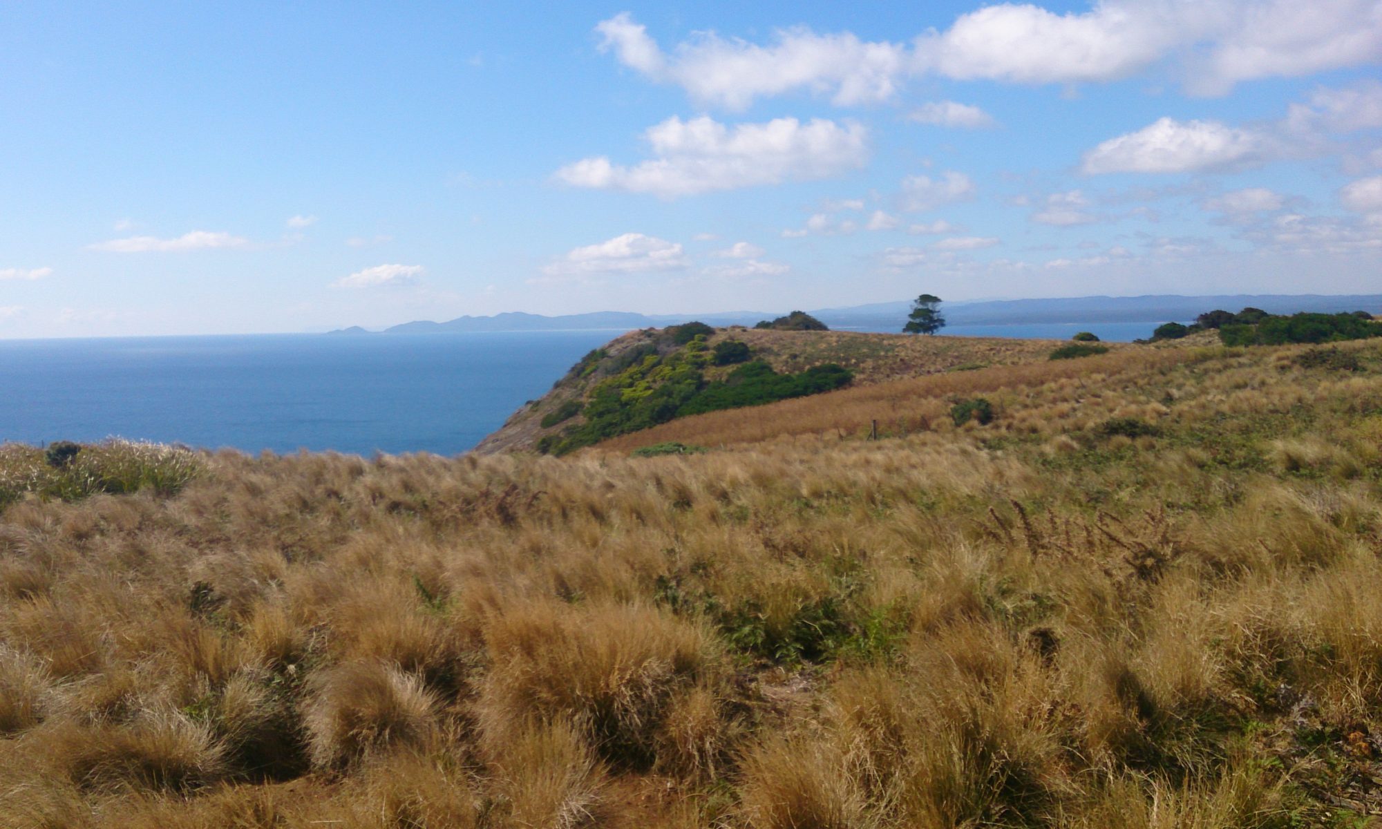
The Nut. An awe-inspiring volcanic plug. A stunning backdrop for photos of Stanley. A pleasant stroll? Listed as one of Tasmania’s 60 Great Short Walks, the hike up to the top is no mean feat! With views of pinmatik/Rocky Cape, Table Cape and Highfield House, The Nut will quite literally take your breath away.

Tatlows Beach © emily@traversingtasmania 2018

The Nut is a unique rock formation in the town of Stanley, north west Tasmania. It rises 143 metres and is a little bit like Uluru: a giant rock that appears seemingly in the middle of nowhere. Originally named Circular Head (which is now the name of the surrounding region), it was possibly called The Nut after its Tasmanian Aboriginal name, munatrik, or perhaps because not even explosives could make a dent in it.

Stanley Trig Point
Stanley Trig Point © emily@traversingtasmania 2018

What’s up there? You’ll find a circuit track, a Parks and Wildlife reading room, Stanley trig point and a surprising array of flora and fauna. My favourite way to do the 2.3 km circuit is to head left through the button grass first. I love to gaze out at Bass Strait and pinmatik/Rocky Cape National Park.

Picnic
Picnic © emily@traversingtasmania 2018

As you begin to go around the opposite side, you’ll have views of Smithton, Tatlows Beach, Stanley, and even directly down to the fisherman’s wharf. You’ll find fenced lookouts and plenty of benches to sit on. The most unexpected sight is a forested fairy-tale grove, replete with pademelon and even picnic tables to sit on and enjoy the serenity. You won’t want to leave!

What to Bring

The Nut
The Nut © emily@traversingtasmania 2018

Wear sturdy, non-slip shoes for climbing up and down The Nut. You’ll need a small bottle of water too. There are picnic tables at the top (turn right onto the circuit path if you want to reach them faster) so you could bring some food with you. We generally just walk the circuit, take in the views and then descend to Stanley.

Getting There

Views of pinmatik/Rocky Cape
Views of pinmatik/Rocky Cape © emily@traversingtasmania 2018

Drive for two and a half hours from Launceston along the Bass Highway. Stanley is well-signposted. When in Stanley, you can drive to The Nut via Browns Road (accessed via Marshall Street or Harrison Terrace). There is ample parking at the base of The Nut. Alternatively, you can park in Church Street and walk to The Nut directly from town, via a pathway between 50 and 54 Alexander Terrace.

Cost

Tatlows Beach and beyond
Tatlows Beach and beyond © emily@traversingtasmania 2018

It is free and fabulous exercise to walk up The Nut. The chairlift runs in the warmer months. Prices are $16 return and $10 one way for adults. For children, you’ll pay $10 return and $5 one way. Note that the chairlift is closed over winter and can close at any time of the year due to poor weather. If you have health issues that affect your mobility, walking up and down The Nut might be a bit taxing. I would recommend waiting for a non-winter, calm day on which to take the chairlift instead. Whichever way you ascend The Nut, you’ll be glad you’ve made the effort. The Nut’s geology, flora, fauna and views are incredible. Enjoy!

Want more information? Do another of Tasmania’s 60 Great Short Walks. Visit, in person or vicariously, Tasmania’s north west, west coast or north. Travelling further afield? Read about my adventures in Tasmania’s south, east coast, midlands or central highlands.
Goat Island

Traversing Goat Island
Goat Island
Goat Island © emily@traversingtasmania 2017

Just a hop, skip and a jump from mainland Tasmania lies Goat Island. This two-peaked wonderland can be walked to at low tide across a rocky shelf. It is a geologist’s, photographer’s and inner-child’s paradise! You can see east to Ulverstone or west to the Three Sisters as well as discovering wonderful views beneath your feet. I ran around on the rock shelf like a happy kid (no pun intended!) for quite some time before reaching Goat Island proper.

On the island
On the island © emily@traversingtasmania 2017

While I’m not sure where the island got its name, Mr. Traversing Tasmania is a bit of a mountain goat, so he demonstrated one possibility by scampering up the steep, rocky slopes. I stayed down a little lower on “safer” ground but somehow managed to slip anyway! Small tracks will lead you around Goat Island, to the peaks, a cove and a very special cave.

Bass Strait
Bass Strait © emily@traversingtasmania 2017

I’ll get to the cave. First, you must explore the rocky cove with wonderful views of Bass Strait. I found two fascinating rock pools, perhaps the best I’ve ever seen, on top of a rocky ledge. The patterns and textures of Goat Island are incredible. Jagged edges, fiery lichen, unusual seaweed, muscles… the island has it all. To the rear of the cove is a stand of trees covered in vines. It’s a surreal place.

Cave
Cave © emily@traversingtasmania 2017

Walking east around the rocks from the cove, you’ll find the cave. This cave is very unusual because you can crawl through it, there’s a rock pool inside it and it is heart-shaped. Before you get all swoony, the very non-romantic feature of the cave is its fly population. They are in plague proportions. Yuck! Mr. Traversing Tasmania crawled through the cave anyway. Be aware that you will need to climb down the heart-shaped side – don’t rush away from the flies too fast!

Lichen
Lichen © emily@traversingtasmania 2017

The tide will come in, as it always does. You can find updates about the tides here (note that the page shows information for nearby Picnic Point Beach). You want to visit Goad Island when the tide is at a low point (or shortly before this). Do not lose track of time on the island. This is dangerously easy to do but will see you stranded there. While I have no doubt that this would be an adventure in and of itself (and would make for great photos), you’ll miss out on the many other beautiful sights in nearby Ulverstone and Penguin.

What to Bring

Two Peaks
Peaks © emily@traversingtasmania 2017

You’ll need sturdy shoes. The rocks are sharp and you won’t make it over the rock shelf to the island (or around the island to the cave) without them. I always take a back-pack with first aid necessities and I take weather-appropriate gear too. Leave your bathers in the car because this island is for exploring, not relaxing or swimming! Make sure that you bring your camera every part of the island is ridiculously photogenic.

Getting There

Three Sisters
Three Sisters © emily@traversingtasmania 2017

You’ll find Goat Island on Penguin Road, which is the old highway between Ulverstone and Penguin along the coast. Follow Queen Street out of Ulverstone, driving for about five minutes, or Main Road out of Penguin, driving for about ten minutes. Look for signs to Goat Island. There is a small car park across the railway lines but take care as trains do use the railway. Your visit will be restricted by the tide but, if you time it right, you’ll have a lovely experience.

Cost

Cave
Cave © emily@traversingtasmania 2017

Tasmania really is a fabulous place and much of it can be explored for free. Goat Island is no exception. Perhaps you could respect this privilege by taking any litter you find with you. Have a grand adventure on a very unusual island!

Staying in the area for a while? There’s more to see in Tasmania’s north west, north and west coast.

Turners Beach

Traversing Turners Beach
Treasure Hunting
Treasure Hunting © emily@traversingtasmania 2017

This week, we stayed at Turners Beach. The beach faces onto Bass Strait and is strewn with large pebbles, sun-bleached driftwood, seaweed, sponges, cuttlefish and other fascinating offerings from the ocean-floor. At low tide, the sand is revealed, along with more gorgeous pebbles, shells and sponges. Turners beach is a treasure-hunter’s paradise.

High Tide
High Tide © emily@traversingtasmania 2017

At high tide, the only way of moving along the western end of the beach is to walk on the pebbles, which is an adventure. You never know what you’ll find among the driftwood. Unbelievably, there were surfers in the water, taking advantage of the high-tide waves. The sound of the waves dragging back across the rocks is very unusual! It was a fantastic sound to fall asleep to.

Low Tide
Low Tide © emily@traversingtasmania 2017

At low tide, you can walk the length of the beach on the sand. You can also see why there are so many warnings signposted on the public access points to the beach. Sandbars and previously hidden piles of pebbles create brilliant waves but, combined with strong currents, make for less than ideal swimming conditions. Have a lovely paddle and explore the debris instead.

Public Walkway
Public Walkway © emily@traversingtasmania 2017

Public access to Turners Beach is via the esplanade. The most prominent access is via a wooden walkway opposite the popular La Mar Café Providore. This entry has some carparking and two picnic shelters. There is also a viewing platform which is a great spot for taking photos and enjoying the atmosphere of the beach at high tide. When you reach the sand, walk to the right and you’ll find the River Forth. To the left, you’ll find the unusual pebbles and oceanic paraphernalia that make Turners Beach so distinctive.

Getting There

Turners Beach
Turners Beach © emily@traversingtasmania 2017

Turners Beach is approximately 15 minutes’ drive from Devonport along the Bass Highway. Coming from the west, it’s a 5-minute drive from Ulverstone. Drive along the esplanade until you reach the end. Parking is available near the public entry to the beach.

Cost

Turners Beach
Turners Beach © emily@traversingtasmania 2017

There is no cost to visit public beaches in Tasmania. I encourage you to pay for your visit in kind though, by taking three for the sea. I also highly recommend visiting La Mar Café Providore. They have a great menu, lots of options for those with food allergies, a lovely atmosphere and a wonderful variety of food and home-ware items to browse. It’s winter now and sitting beside their wood fire was an absolute treat!

Read more about my adventures in Tasmania’s north west here.

Leven Canyon

Traversing Leven Canyon
Leven Canyon
Leven Canyon © emily@traversingtasmania 2017

Today, it snowed at Leven Canyon in Tasmania’s north west. I know this because I was there. By there, I mean at Cruikshanks Lookout, high above the thundering rapids, being blasted with snow. It was awesome!


Picnic Area
Picnic Area © emily@traversingtasmania 2017

We arrived to a scene from a fairy-tale. Trees towered above us. Ferns surrounded the picnic area. The ground was covered in snow. If we had wanted to, we could have made a fire in the barbeque hut and cooked lunch but I’m glad that we continued to the lookout instead. It was perfect timing.

Track
Track © emily@traversingtasmania 2017

Access to the lookouts is via the Fern Walk (from the lower picnic area) or via the path to Cruikshanks Lookout. The walk can be done as a circuit. I recommend visiting Cruikshanks Lookout first as you can then descend the almost-600 steps to the track below instead of ascending them.

Cruikshanks Lookout
Cruikshanks Lookout © emily@traversingtasmania 2017

When we reached Cruikshanks Lookout, it had just started snowing. The lookout juts out from the hill and is very exposed. Hold on to your hat! The Leven River roared below us and limestone cliffs stood around us at a commanding 300 metres. The wind whipped snow into our faces. It was an incredible sight: Leven Canyon seen through a veil of snow.

Forest Steps
Forest Steps © emily@traversingtasmania 2017

Descend the (many!) Forest Steps to the Edge Lookout below for another spectacular view. This time, you’re much closer to the rapids but still at quite a height above them. As always with Tasmania, the weather can change at any moment. When we stepped out onto the Edge Lookout, we were greeted with the warmth of the sun (and a small pocket of phone reception!).

Leven River
Leven River © emily@traversingtasmania 2017

From the Edge Lookout, it’s an easy walk back to the carpark. Well, almost! There might not be any steps but the uphill trudge was hard-going! The track is well-maintained. There are benches at regular intervals along the circuit’s tracks. These are essentially horizontal signposts, showing you how far you are from the nearest location (car park, bridge, lookout) in either direction and are a great motivation to keep going!

Getting There

Roadside View
Roadside View © emily@traversingtasmania 2017

The Leven Canyon Lookout is approximately 45 minutes’ drive from Ulverstone via the B15 or the B17 (the latter goes past the turnoff to Wings Wildlife Park). The drive there was very picturesque, with snow beside the road and on the distant mountain tops. As always with Tasmania’s country roads, take care on corners, particularly on icy days like today. When you arrive at Leven Canyon, there is ample car parking. Watch out for our native animals.

Cost

Leven Canyon
Leven Canyon © emily@traversingtasmania 2017

There are no entry fees at Leven Canyon. Toilet and wood-fired barbeque facilities are available for public use. Do not light the barbeques during a total fire ban! There are also plenty of picnic tables for public use. It’s a great spot to visit.

You can read more about my adventures in Tasmania’s beautiful north west here.

Mersey Bluff Reserve

Traversing Mersey Bluff Reserve
Mersey Bluff Reserve
Mersey Bluff Reserve © emily@traversingtasmania 2017

Last week, I visited the lovely Mersey Bluff Reserve. Dubbed “The Bluff” by locals, it has a rugged beauty, excellent facilities and is a significant location in punnilerpunner country. In summer, Mersey Bluff Reserve is crowded with swimmers, diners, children playing on the playground and people walking or running by. In winter, I arrived to find a man wheeling a car tyre past the playground and saw approximately fifteen people across the entire reserve. Everyone who stayed away because of the rain missed out though.

Walkway
Walkway © emily@traversingtasmania 2017

When you arrive at Mersey Bluff Reserve, you’ll see a giant playground, a beach, and a fascinating building, which houses the amenities and eateries. I recommend having a bite to eat here as the view is superb. Walk north along the beach and you’ll see a cement track. This leads you around The Bluff. It is a short but stunning walk. On a sunny day, at the right time, you’ll even see The Julie Burgess about (this is how I first learnt that she existed!) or The Spirit of Tasmania sail past.

View of Bass Strait
View of Bass Strait © emily@traversingtasmania 2017

One of my friends recently told me that she loves to go to the beach in winter. Now I understand why! I have never seen the water so wild before. Waves pushed up to the cement barrier on the beach. They pounded the cliffs and surged through the rocks. I stood at one lookout and watched the water pour in and out of a crevice for about five minutes. It was amazing!

Memorial
Memorial © emily@traversingtasmania 2017

I followed a father and his two sons around the track. One of the boys asked his father to read him a plaque. His father read out a poignant statement about a man who died in 1929 trying to save a little girl. Near the lighthouse, there is another plaque about a man who died more recently, again, trying to save someone else. For the sake of others, please swim only at the beach and not near the cliffs.

Lighthouse
Lighthouse © emily@traversingtasmania 2017

The lighthouse is testament to the perils of The Bluff and of Bass Strait. It is a rather gorgeous red and white striped lighthouse, perched on the cliffs overlooking Bass Strait. You first see it from a lookout just off the walkway. You cannot climb the lighthouse but admiring it from the outside is good enough.

As you walk back down the hill, you’ll see two things: a caravan park and Tiagarra. This is no accident, as a sign at Tiagarra, an Aboriginal Cultural Centre, points out: “Wherever there is a caravanpark or campsite on the ocean or rivers it is likely to be built on an Aboriginal living site, as they are in the best positions to stay in the seasons”. Tiagarra means “to keep” and is one of the oldest Aboriginal Keeping Places in Australia. Take time to read the poetry printed on the windows and to look for petroglyphs (carvings) on the rocks near the lighthouse. Tiagarra is open by appointment for groups of ten or more.

Tiagarra
Tiagarra © emily@traversingtasmania 2017

Getting There

Lighthouse
Lighthouse © emily@traversingtasmania 2017

Devonport is about one hour’s drive north of Launceston on the Bass Highway and about half an hour east of Burnie. When you arrive in Devonport, head to the city centre. From here, follow Victoria Parade. This then turns into Bluff Road. There is plenty of car parking at The Bluff. If you’re keen on exercise, there is a cycling and walking track that runs alongside the river from the city to The Bluff. It is rather picturesque!

Cost

Mersey Bluff Reserve
Mersey Bluff Reserve © emily@traversingtasmania 2017

There is no cost to visit Mersey Bluff Reserve or to walk around the base of the lighthouse. If you make an appointment to visit Tiagarra (with a group of ten or more), you can purchase craft and artworks. Alternatively, buy some food at one of The Bluff restaurants or have a picnic at one of the picnic tables. I’ve always enjoyed visiting The Bluff and, as my winter visit proved, the loop walk around the coast is worth doing at any time of year.

Staying in Devonport? Read about my visits to Home Hill, Bass Strait Maritime Centre or The Julie Burgess. Passing through? Read about my adventures in Tasmania’s nearby north west or north.

Tasmazia and the Village of Lower Crackpot

Traversing Tasmazia and the Village of Lower Crackpot
Tasmazia and the Village of Lower Crackpot
Tasmazia and the Village of Lower Crackpot © emily@traversingtasmania 2017

Tasmazia and the Village of Lower Crackpot is, pardon the pun, amazing. Laugh your way through the maze, with another joke just around the corner. Be propelled at lightning speed back to your childhood as you find what’s around the corner and climb through small spaces. Above it all stands the imposing, gorgeous Mount Roland. If you haven’t been to Tasmazia yet, then you need to plan to visit soon!

The House of Hadd
The House of Hadd © emily@traversingtasmania 2017

Winter in Tasmania means the winter blues combined with a good dose of cabin fever for many Tasmanians. You can beat the winter blues with a good laugh as you make your way through the Great Maze at Tasmazia. Named due to its towering hedges (even the tallest of adults can’t cheat in this maze!), the Great Maze is full of surprises, including the Three Bears House, a garden path and a monumental toilet. It’s a real hoot!

Balance Maze
Balance Maze © emily@traversingtasmania 2017

On the edge of the Great Maze are several other treats. Whizz down a fireman’s pole, make your way through the spooky house (the spookiest thing being how dark the maze through it is!) and wobble your way across the balance maze. If you want, you can even put yourself (or somebody else!) in the stocks. Kids will love this part of the maze but I can tell you that it was great fun as an adult too. I’m proud to say that I made it through the balance maze without falling off!

Once you’re finished with the Great Maze and the other attractions on its edge, there’s more! You’ll now find yourself in the Village of Lower Crackpot. This is a quirky, miniature village surrounded by four smaller mazes. The buildings in the village include tributes to local groups such as the Salvation Army and the State Emergency Services, as well as crazy, humorous buildings like the University of Lateral Thinking. The inventors of Tasmazia and the Village of Lower Crackpot do have a sense of humour! You can overlook the village from The Tower.

Yellow Brick Maze
Yellow Brick Maze © emily@traversingtasmania 2017

This part of Tasmazia has a stunning outlook of Mount Roland. As you make your way through the four smaller mazes, be sure to look up for a great view! There are three quirky hedge mazes and a paved maze filled with humorous buildings (look out for the Boot Camp!). If you’re feeling mazed-out, the best view is from the end of the Yellow Brick Maze and the funniest centre-piece is in the Hexagonal Maze.

Embassy Gardens
Embassy Gardens © emily@traversingtasmania 2017

The final attraction at Tasmazia and the Village of Lower Crackpot is the Embassy Gardens. This houses the miniature and humorous (can you see the theme?!) embassies of several countries. Make sure that you ring Belgium’s bell. Mothers, take refuge in your safe space (complete with another great view of Mount Roland!). Once you’ve finished here, it’s out the gates and to the loo.

The Village of Lower Crackpot
The Village of Lower Crackpot © emily@traversingtasmania 2017

Tasmazia and the Village of Lower Crackpot boasts the best ladies’ toilets on the planet. The cubicles are very roomy, each with its own painting and chair! There is a small gift shop and a café. While you won’t find gourmet food there (aside from the honey for sale), it is tasty, served quickly and dietary requirements can be catered for.

What to Bring

The Crapper Monument
The Crapper Monument © emily@traversingtasmania 2017

The most important thing to bring with you is a sense of adventure! Wear sturdy shoes and comfortable clothes as you’ll be outdoors for a good half day at least. Take a hat and sunscreen in summer and wear a warm coat, hat and gloves in winter. You can exit and then re-enter the maze as often as you wish but it might be wise to take a bottle of water and snacks with you. There is no (usable) toilet in the maze so keep this in mind too!

Getting There

A joke around every corner
A joke around every corner © emily@traversingtasmania 2017

Tasmazia and the Village of Lower Crackpot is about a 15 minute drive west from the town of Sheffield. From Devonport, drive south via Spreyton. From Launceston, drive north on the Bass Highway, taking the left-hand turn at Elizabeth Town for Sheffield. If you’re travelling from Cradle Mountain to Sheffield (or vice versa), Tasmazia is well worth the slight detour.

Cost

Post Office
Post Office © emily@traversingtasmania 2017

At $25 per adult, you may think that Tasmazia is a bit overpriced. Entry costs $20 per senior, $70 per family (2 + 2) and $12.50 for children (with children under four free).  I would pay the entry fee again in a heartbeat. It is worth every cent for a good laugh and a fabulous adventure!

In nearby Sheffield, you’ll find the Redwater Creek Railway, which I enjoyed visiting a few weeks earlier. For more posts about my travels in Tasmania’s north west, click here, and for more in the north, click here.