Stanley

The Nut and Stanley
Little penguin colony
Little penguin colony © emily@traversingtasmania 2018

When I was a kid, I never knew what my favourite animal was because I had too many. I particularly hated being asked, “If you could be any animal, which would you choose?” For some reason, this question would be asked of my class from time to time and I could never give an answer that I was happy with. I can now say that I’d like to be a little penguin (or a short-tailed shearwater). It has nothing to do with flying or swimming but rather with the places that they live, which also happen to be my favourite spots in Tasmania: Bruny Island in the south, Bicheno on the east coast and Stanley in the north west.

The Nut
The Nut © emily@traversingtasmania 2018

In addition to being home to a colony of little penguins, Stanley also boasts The Nut (a volcanic plug), a lovely community, a picturesque outlook, beaches, fabulous shopping, heritage sites and beef and fishing industries. I could spend weeks in Stanley. Strangely enough, as it goes against the tourist trend, my favourite time to visit is during the winter months. It’s the light. The air is clear and crisp, the fields so green and the sea so blue and the sunrises and sunsets are spectacular. And, let’s be honest, who would climb The Nut in the summer months?

The Angel's Share
The Angel’s Share © emily@traversingtasmania 2018

If you’re travelling to Stanley just for the day or the weekend, make sure that you arrive when the shops are open. My favourites are The Angel’s Share and Hearts N Crafts. You’ll find boutique clothing and accessories as well as Tasmanian whisky and spirits at The Angel’s Share and lots of homemade goodies at Hearts N Crafts. You’re sure to find something that appeals as you wander along Church Street.

Fishing Boat
Fishing Boat © emily@traversingtasmania 2018

Originally a fishing village, the fisherman’s wharf is a great spot to visit. Take a photo of the red boats against the backdrop of the sea or have a bite to eat at Hursey’s Seafood or buy frozen seafood from the Stanley Seaquarium. For a good coffee, visit Black Dog on Church Street. Locals rave about the food at Xanders too and highly recommend the summer barbecues etc. put on by them.

Highfield House
Highfield House © emily@traversingtasmania 2018

For a small town, Stanley has its fair share of historic buildings. A trip to Stanley wouldn’t be complete without a visit to Highfield House, the impressive homestead built by the Van Dieman’s Land Company in the 1830s. You’ll have stellar views of The Nut and Stanley from here. In town, you’ll find former-prime minister and Tasmanian premier Joseph Lyon’s birthplace. The old cottages, churches and buildings are lovely – be sure to have a good look around.

The Nut
The Nut © emily@traversingtasmania 2018

Finally, head up The Nut (you can read about my visit here) and enjoy the beaches. You’ll find the little penguin colony at Godfrey’s Beach. It’s a short but picturesque beach with gorgeous views of The Nut, Highfield House and Bass Strait. On the other side of town, you’ll find Tatlows Beach. It offers a longer walk and views of The Nut, Rocky Cape National Park, Port Latta and so on. You’ll enjoy breathing in the fresh sea air, no matter what the time of year.

What to Bring

Abbey’s Cottage © emily@traversingtasmania 2018

Bring sturdy shoes, weather-appropriate clothing and a camera so that you can enjoy all that Stanley has to offer. I like to bring basic food supplies although the town does have a well-stocked IGA and fabulous goods in the stores on Church Street. Having a red light torch for penguin viewing is also a must along with warm clothes as this is a night-time activity. Bring a good book too. Stanley is a place for relaxing.

Getting There

Tatlows Beach
Tatlows Beach © emily@traversingtasmania 2018

Stanley is approximately a two-and-a-half-hour drive from Launceston or about a five-hour drive from Hobart. If you’re visiting for the day, you’ll find plenty of free parking in the town’s streets. The larger towns are Smithton and Wynyard. You’ll find the natural beauty of Rocky Cape National Park and Boat Harbour nearby too. If you’re visiting Tasmania, I highly recommend taking the time to explore this area as it is stunning.

Cost

Godfrey's Beach
Godfrey’s Beach © emily@traversingtasmania 2018

Attractions at Stanley range in price and opening hours. For free, you can climb The Nut, walk the beaches, use the public barbecues, explore the shops, take photos and visit Joe Lyon’s Cottage. You’ll pay to visit Highfield House, Stanley Seaquarium, Stanley Golf Course and to take the chairlift up The Nut. You can also cruise around The Nut with Stanley Seal Cruises or take a helicopter flight over the area if you wish to with Osbourne Heli Tours. Basically, a trip to Stanley can be as affordable or as lavish as you would like it to be. I highly recommend making like a little penguin and visiting one of my favourite Tasmanian towns.

Want to explore the region? Read about my travels in Tasmania’s north west. Travelling further afield? I’ve traversed the west coast, south, east coast, north, midlands and central highlands and can highly recommend several places to visit in each area.
The Nut

Traversing The Nut
The Nut
The Nut © emily@traversingtasmania 2018

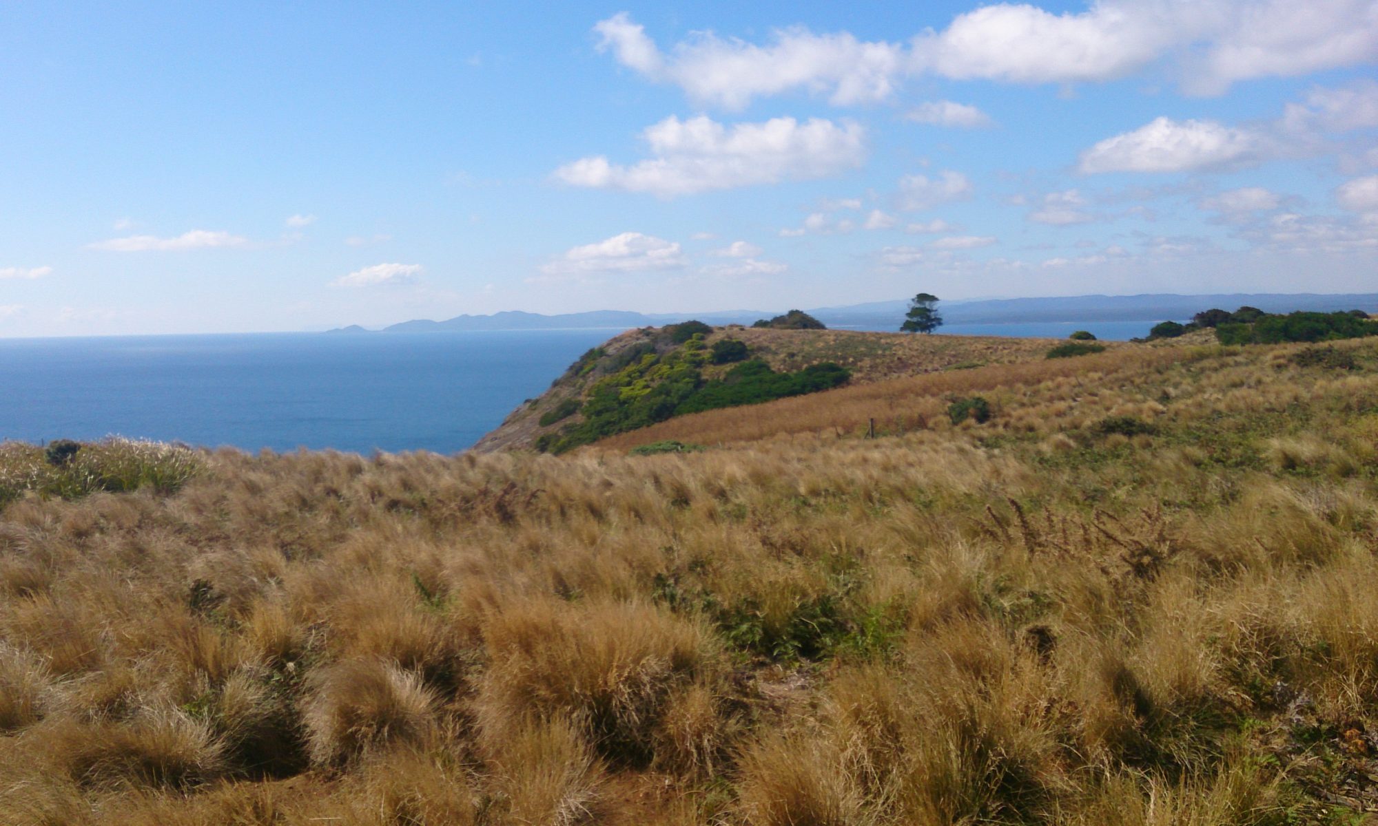
The Nut. An awe-inspiring volcanic plug. A stunning backdrop for photos of Stanley. A pleasant stroll? Listed as one of Tasmania’s 60 Great Short Walks, the hike up to the top is no mean feat! With views of pinmatik/Rocky Cape, Table Cape and Highfield House, The Nut will quite literally take your breath away.

Tatlows Beach © emily@traversingtasmania 2018

The Nut is a unique rock formation in the town of Stanley, north west Tasmania. It rises 143 metres and is a little bit like Uluru: a giant rock that appears seemingly in the middle of nowhere. Originally named Circular Head (which is now the name of the surrounding region), it was possibly called The Nut after its Tasmanian Aboriginal name, munatrik, or perhaps because not even explosives could make a dent in it.

Stanley Trig Point
Stanley Trig Point © emily@traversingtasmania 2018

What’s up there? You’ll find a circuit track, a Parks and Wildlife reading room, Stanley trig point and a surprising array of flora and fauna. My favourite way to do the 2.3 km circuit is to head left through the button grass first. I love to gaze out at Bass Strait and pinmatik/Rocky Cape National Park.

Picnic
Picnic © emily@traversingtasmania 2018

As you begin to go around the opposite side, you’ll have views of Smithton, Tatlows Beach, Stanley, and even directly down to the fisherman’s wharf. You’ll find fenced lookouts and plenty of benches to sit on. The most unexpected sight is a forested fairy-tale grove, replete with pademelon and even picnic tables to sit on and enjoy the serenity. You won’t want to leave!

What to Bring

The Nut
The Nut © emily@traversingtasmania 2018

Wear sturdy, non-slip shoes for climbing up and down The Nut. You’ll need a small bottle of water too. There are picnic tables at the top (turn right onto the circuit path if you want to reach them faster) so you could bring some food with you. We generally just walk the circuit, take in the views and then descend to Stanley.

Getting There

Views of pinmatik/Rocky Cape
Views of pinmatik/Rocky Cape © emily@traversingtasmania 2018

Drive for two and a half hours from Launceston along the Bass Highway. Stanley is well-signposted. When in Stanley, you can drive to The Nut via Browns Road (accessed via Marshall Street or Harrison Terrace). There is ample parking at the base of The Nut. Alternatively, you can park in Church Street and walk to The Nut directly from town, via a pathway between 50 and 54 Alexander Terrace.

Cost

Tatlows Beach and beyond
Tatlows Beach and beyond © emily@traversingtasmania 2018

It is free and fabulous exercise to walk up The Nut. The chairlift runs in the warmer months. Prices are $16 return and $10 one way for adults. For children, you’ll pay $10 return and $5 one way. Note that the chairlift is closed over winter and can close at any time of the year due to poor weather. If you have health issues that affect your mobility, walking up and down The Nut might be a bit taxing. I would recommend waiting for a non-winter, calm day on which to take the chairlift instead. Whichever way you ascend The Nut, you’ll be glad you’ve made the effort. The Nut’s geology, flora, fauna and views are incredible. Enjoy!

Want more information? Do another of Tasmania’s 60 Great Short Walks. Visit, in person or vicariously, Tasmania’s north west, west coast or north. Travelling further afield? Read about my adventures in Tasmania’s south, east coast, midlands or central highlands.

Tailrace Park

Traversing Tailrace Park
River Views
River Views © emily@traversingtasmania 2018

It is such a delight to find one of Tasmania’s hidden gems. This is, admittedly, a very small gem but it is beautiful nonetheless. And it is hidden. Even Google maps haven’t discovered it yet, or at least not the boardwalk part of it! I’ve been out to Tamar Island several times but what I didn’t realise is that there is another boardwalk that leads you out onto the Tamar River. The Tailrace Park has its own version, allowing you to emerge from the dense tree-line onto the river proper.

Yacht
Yacht © emily@traversingtasmania 2018

As the name suggests, Tailrace Park is located next to a tailrace, this one from the Trevallyn Hydroelectric Power Station. I find the tailrace itself fascinating and beautiful. First, you’ll see a recently constructed embankment beneath the road. The turbulence of the tailrace eroded the previous embankment away, such is the force of moving water. Next, you’ll spy a yacht or two as well as pelicans. We talked to someone who spotted a seal in the water just after we had visited. I guess it’s a great place for a seal spa bath!

Flora
Flora © emily@traversingtasmania 2018

When you reach Tailrace Park proper, keep left (you’ll need to head around the boatshed though) and you’ll find the boardwalk. This leads through the scrub and trees to a picnic table with more views of the tailrace. Walk on and you’ll find yourself on the river’s edge. There is something hauntingly beautiful about the place where the bush meets the water. This part of the river reminds me of the west coast.

Tamar River
Tamar River © emily@traversingtasmania 2018

You’ll also spot some lovely sights such as the new Silos Hotel (if you look hard!) and the old shipyards. Both speak of Launceston’s past as a port. You’ll understand, when you look down at the deep mud beneath your feet, that the port’s heyday was always going to end at some point.

Tailrace Park
Tailrace Park © emily@traversingtasmania 2018

At the end of the boardwalk, you’ll emerge back into Tailrace Park. I must admit that I was tempted to have a go on the very tall slide. If you’ve brought some snags, you can cook them on one of the Rotary sponsored public barbecues.

Getting There

Walk
Walk © emily@traversingtasmania 2018

You’ll find Tailrace Park on West Tamar Road, opposite the Trevallyn Hydroelectric Power Station. It is about 5 – 10 minutes’ drive from Launceston’s CBD or a leisurely one hour walk. There is ample on-site free parking.

Cost

Tamar River
Tamar River © emily@traversingtasmania 2018

Free parking, barbeques, picnic tables, a park, slides, a boardwalk, wildlife, river views… You’ll have a lot of fun for zero cost at Tailrace Park. My only regret was that I had to leave! Enjoy one Tasmania’s lovely free parks.

Read on for more adventures in Tassie’s north, midlands or north-west or take your journey one step further and cruise the Tamar River. Looking for another free, short walk? Try nearby Cataract Gorge Reserve or Tamar Island.

Ocean Beach

Traversing Ocean Beach
View from Ocean Beach Lookout
View from Ocean Beach Lookout © emily@traversingtasmania 2018

Ocean Beach is a 30+ km beach highway (for the right vehicle at the right time of day). You’ll see towering sand dunes, rolling waves and white, white sand. It’s a wild place. Just to give you can idea of how untamed it is, Ocean Beach lies between Hell’s Gates in the south and Trial Harbour in the north. Both places were named to let other travellers know what to expect in these waters: great difficulty!

Beach Highway
Beach Highway © emily@traversingtasmania 2018

You can drive onto Ocean Beach with a 4WD vehicle at several points. We entered the beach at Macquarie Heads. Macquarie Heads is particularly picturesque with views of historic lighthouses, fisherman’s cottages and rock walls as well as the dangerous Hell’s Gates passage out of Macquarie Harbour. It was a delight to drive in the blue water of our GPS screen while safely on Ocean Beach!

Ocean Beach
Ocean Beach © emily@traversingtasmania 2018

While I was walking by the waves at Ocean Beach Lookout, Mr. Traversing Tasmania tried to get the 4WD down the track to the shore but decided that he wasn’t brave enough! Ask locals for advice about when and where to access the beach. Note that there are two river mouths to cross and that you can get bogged. That’s not on my list of things to do while on holiday!

What to Bring

Ocean Beach
Ocean Beach © emily@traversingtasmania 2018

If you’re planning on driving your 4WD along Ocean Beach, bring recovery equipment and let someone know where you’re going and when to expect you back. It also helps to ask locals about which access points are currently safe to use. Bring your fishing gear for use at Macquarie Heads. Note that Ocean Beach is unpatrolled by lifeguards and is too dangerous for swimming. Bring food and water so that you can stay as long as you please and, as always on the west coast, bring clothing appropriate for wet, windy and/or cold weather.

Getting There

View north
View north © emily@traversingtasmania 2018

If you don’t have a 4WD, you can still enjoy Ocean Beach. Just follow signs from Strahan along C250, Ocean Beach Road. A sign-posted right-hand turn and a short stretch of dirt road will see you arrive at the car park at Ocean Beach Lookout. Here, walk a wild stretch of sand with views of Macquarie Heads to the south or views of Henty Dunes and rugged ranges to the north. Just being beside the ocean is wonderfully restorative. I’m told by the locals that Ocean Beach is also one of the best spots to view the sunset.

Cost

Dunes
Dunes © emily@traversingtasmania 2018

Access to Tasmania’s beaches is free! This is something that I don’t take for granted. I do my part by taking all of my rubbish away with me. I also take three additional pieces of rubbish (bottle caps, gum wrappers, fishing line and the like) with me to do my bit for the ocean critters who don’t need waste in their environment. Enjoy the pristine wilderness that is Ocean Beach!

To read about more of my west coast adventures, click here.

Hogarth Falls

Traversing Hogarth Falls
Peoples Park
Peoples Park © emily@traversingtasmania 2018

Strahan is a small town on Tassie’s rugged west coast. Just a short walk from Strahan’s waterfront is Peoples Park, with its lovely wrought iron gates. Inside the borders of Peoples Park is one of Tasmania’s 60 Great Short Walks. At the end of this walk is the final part of this proverbial Matyroshka doll: Hogarth Falls.

Walking Track
Walking Track © emily@traversingtasmania 2018

If you want to experience the wilds of the west coast but are limited by time or transportation, Hogarth Falls is a short, pram-friendly taster of the area. You’ll pass by tannin-stained creeks that meander through deep-green foliage. Take in the view of the rain-forest’s canopy above you and the sound of the birds. It is serene.

Hogarth Falls
Hogarth Falls © emily@traversingtasmania 2018

At the end of the track, a small but picturesque waterfall awaits you. Hogarth Falls is refreshingly unpretentious (and relatively untouched). It is surrounded by moss, ferns, and intricate rock formations. It is a lovely place to pause and revel in your surroundings. You can almost imagine the piners (timber cutters) of old and their families having a picnic on the rocks below the falls or perhaps members of the Toogee kinship group (Tasmanian Aboriginals) soaking in the raw beauty of their home. Tasmania is a wonderful place and Hogarth Falls is testament to this.

What to Bring

Rainforest
Rainforest © emily@traversingtasmania 2018

As always on the west coast, dress for rain. It rains a lot! Sturdy shoes are also a must as the track becomes muddy quite quickly. Even though the walk is relatively quick and easy (30 – 45 minutes), I recommend carrying water and basic first aid supplies. You’ll start and end of your journey in Peoples Park where there is a well-maintained amenities block.

Getting There

Peoples Park
Peoples Park © emily@traversingtasmania 2018

Strahan is about four hours’ drive from Launceston or about four and a half hours’ drive from Hobart. You only have to walk for 10 – 15 minutes from Strahan’s port area to find yourself in Peoples Park. If you choose to drive, there is ample free parking onsite.

Cost

Stairs from Hogarth Falls
Stairs from Hogarth Falls © emily@traversingtasmania 2018

All of Tasmania’s 60 Great Short Walks are free, which is wonderful! Enjoy Tassie’s wilds but remember to do your part by taking your rubbish with you. Save your pennies for a once-in-a-lifetime experience like the Gordon River Cruise.

There are many things to do on the west coast. Read on for more ideas!

Goat Island

Traversing Goat Island
Goat Island
Goat Island © emily@traversingtasmania 2017

Just a hop, skip and a jump from mainland Tasmania lies Goat Island. This two-peaked wonderland can be walked to at low tide across a rocky shelf. It is a geologist’s, photographer’s and inner-child’s paradise! You can see east to Ulverstone or west to the Three Sisters as well as discovering wonderful views beneath your feet. I ran around on the rock shelf like a happy kid (no pun intended!) for quite some time before reaching Goat Island proper.

On the island
On the island © emily@traversingtasmania 2017

While I’m not sure where the island got its name, Mr. Traversing Tasmania is a bit of a mountain goat, so he demonstrated one possibility by scampering up the steep, rocky slopes. I stayed down a little lower on “safer” ground but somehow managed to slip anyway! Small tracks will lead you around Goat Island, to the peaks, a cove and a very special cave.

Bass Strait
Bass Strait © emily@traversingtasmania 2017

I’ll get to the cave. First, you must explore the rocky cove with wonderful views of Bass Strait. I found two fascinating rock pools, perhaps the best I’ve ever seen, on top of a rocky ledge. The patterns and textures of Goat Island are incredible. Jagged edges, fiery lichen, unusual seaweed, muscles… the island has it all. To the rear of the cove is a stand of trees covered in vines. It’s a surreal place.

Cave
Cave © emily@traversingtasmania 2017

Walking east around the rocks from the cove, you’ll find the cave. This cave is very unusual because you can crawl through it, there’s a rock pool inside it and it is heart-shaped. Before you get all swoony, the very non-romantic feature of the cave is its fly population. They are in plague proportions. Yuck! Mr. Traversing Tasmania crawled through the cave anyway. Be aware that you will need to climb down the heart-shaped side – don’t rush away from the flies too fast!

Lichen
Lichen © emily@traversingtasmania 2017

The tide will come in, as it always does. You can find updates about the tides here (note that the page shows information for nearby Picnic Point Beach). You want to visit Goad Island when the tide is at a low point (or shortly before this). Do not lose track of time on the island. This is dangerously easy to do but will see you stranded there. While I have no doubt that this would be an adventure in and of itself (and would make for great photos), you’ll miss out on the many other beautiful sights in nearby Ulverstone and Penguin.

What to Bring

Two Peaks
Peaks © emily@traversingtasmania 2017

You’ll need sturdy shoes. The rocks are sharp and you won’t make it over the rock shelf to the island (or around the island to the cave) without them. I always take a back-pack with first aid necessities and I take weather-appropriate gear too. Leave your bathers in the car because this island is for exploring, not relaxing or swimming! Make sure that you bring your camera every part of the island is ridiculously photogenic.

Getting There

Three Sisters
Three Sisters © emily@traversingtasmania 2017

You’ll find Goat Island on Penguin Road, which is the old highway between Ulverstone and Penguin along the coast. Follow Queen Street out of Ulverstone, driving for about five minutes, or Main Road out of Penguin, driving for about ten minutes. Look for signs to Goat Island. There is a small car park across the railway lines but take care as trains do use the railway. Your visit will be restricted by the tide but, if you time it right, you’ll have a lovely experience.

Cost

Cave
Cave © emily@traversingtasmania 2017

Tasmania really is a fabulous place and much of it can be explored for free. Goat Island is no exception. Perhaps you could respect this privilege by taking any litter you find with you. Have a grand adventure on a very unusual island!

Staying in the area for a while? There’s more to see in Tasmania’s north west, north and west coast.